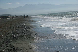
Recently, my sister and brother-in-law were in town visiting so Kelly and I thought it would be fun for all of us to drive over to the Dungeness National Wildlife Refuge, located about an hour’s drive from our house.
In my opinion, the main attraction of the refuge is a long extension of land mass known as the Dungeness Spit. At just over 5.5-miles (8.9 km) in length, this sand spit juts out from the northern edge of the Olympic Peninsula, into the Strait of Juan de Fuca.
It seems that this spit is in fact the longest natural sand spit in the United States. Its land area, according to the United States Census Bureau is 1,271,454 square meters (0.4909 sq mi, or 314.18 acres).
Not content to rest upon its laurels, this lengthy land mass continues to swell, little by little, day be day. Literally extending itself 5 miles into the seas, the spit has unassumingly stretched its crooked finger into the strait at roughly of 15 feet per year for the past 120 years.
I was wondering why the spit continues to grow, rather than slowly wash away in the incessant waves crashing all around.
Much to my surprise, erosion is kept at bay due to complex winds, waves, and importantly, the eroding neighboring bluffs to the southwest.
Water is a formidable opponent, and these seemingly mighty bluffs have no choice but to surrender themselves to the relentless and never-ending waves. Slowly, yet with all the will of a heavyweight champ, the waves eventually overcome the bluffs, their pounding effective like well placed body blows to the torso. The resulting KO seems inevitable.
Defeated, the sediment of the eroded bluffs simply fall victim to the tidal currents and before they know what has happened, find themselves anchored alongside the spit, hence a catalyst and material for growth. Then, as elsewhere in nature, the process repeats itself.
Collaborating in the spit’s advancement are the strong northeast gusts, which reverse shore drift; the process corroborating nature’s will. In this case forming the Graveyard Spit ‘hook’.
 During our visit, park staff told us that many, if not most visitors do walk the short route to the base of the spit, but only a small percentage of these same visitors actually extend their hike to the lighthouse located near the end of the spit (presumably, in 1858 the lighthouse was at the end of the spit).
Having completed the journey myself, I now appreciate why many do not advance to the lighthouse. It’s not that the trek to the lighthouse is terribly difficult; it’s just that a 10-mile hike is simply that - 10 miles.
Moreover, tides have a major impact on the walking surface of the spit, and depending upon when one starts out, the path will be hard-packed sand, or it won’t. We got the benefit of mostly hard pack on the way out, but coming back a high tide forced us to navigate atop deep sand and rocks.
the walk back
wood litters the area
wood up close
being a wildlife refuge, birds are everywhere
flying away
It is also worth noting that the salt water has an odd way of transforming itself to salty air. At one point it hit me that I was covered in salt sediment - my sunglasses and camera lenses taking an unfair share of the punishment.
All in all, the trip to Dungeness Spit was a very good day trip and I highly recommend others take time to visit.
Maybe if you are lucky, you might spot a nuclear submarine headed to the Pacific Ocean … we did.


No comments:
Post a Comment